�ç��� : ����֡��ʶҹ�Ҿ����Ƿҧ㹡�������ª������ŷ�Ѿ�ҡ÷��Թ�ͧ˹��§ҹ�Ҥ�Ѱ
�ش�ç����Ԩ������ǡѺ��Ѿ�ҡôԹ��з��Թ
�� ��������ʵ�Ҩ���� ���ѵ� �������ͧ �Ҥ�ԪҸó��Է�� ����Է����ʵ�� ����ŧ�ó�����Է����� ��������ʵ�Ҩ���� ���ѵ� �������ͧ �Ҥ�ԪҸó��Է�� ����Է����ʵ�� ����ŧ�ó�����Է�����
�ٹ���Ԩ���������ʹ�����ͻ������ ����ŧ�ó�����Է����� [ GISTHAI ]
e - mail : [email protected]
ʹѺʹع���ӹѡ�ҹ�ͧ�عʹѺʹع����Ԩ�� (ʡ�.)
���Ѵ���
㹻Ѩ�غѹ ��þѲ����С�èѴ��÷�Ѿ�ҡôԹ�������ö���Թ��������ҧ������ ��駹�����ͧ�ҡ���ʺ�ѭ�������ͧ�ͧʶҹ�Ҿ�����ŷ��Ѵ����˹��§ҹ�Ҥ�Ѱ����ѧ�Ҵ ���������§�ͧ������ ����š����¹������ ��������ó�ͧ������ ����֧�ҵðҹ�ͧ������ �����˵ؼŴѧ����Ǩ֧��Ѵ�� �ç��� "�֡��ʶҹ�Ҿ����Ƿҧ㹡�������ª������ŷ�Ѿ�ҡôԹ�ͧ˹��§ҹ�Ҥ�Ѱ" �����ѵ�ػ��ʧ�������֡��
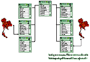 ����Ǻ����ѭ����¡�â����ŷ��˹��§ҹ��ҧ� ��Ѵ��������� �ҨѴ���ҧ�繰ҹ������ �����Ţͧ������ (Metadata) ��ٻ�ͧ�к����ʹ��������ʵ�� (GIS) ����к����ʹ�����͡�èѴ��� (MIS) �����駨Ѵ�����������ء���Ẻ���������������ö��Ҷ֧�����������ҧ�дǡ����Ǵ���� ��觡���֡��㹤��駹���ѧ���͡Ẻ���Ǩ���������ɳ�ؤ�ҡâͧ˹��§ҹ�Ҥ�Ѱ����Ѻ�Դ�ͺ�����ŷ������Ǣ�ͧ�Ѻ��Ѿ�ҡôԹ�ӹǹ 13 ��鹢����� ����˹��§ҹ����������Ǩ�ӹǹ������ 22 ˹��§ҹ ����Ǻ����ѭ����¡�â����ŷ��˹��§ҹ��ҧ� ��Ѵ��������� �ҨѴ���ҧ�繰ҹ������ �����Ţͧ������ (Metadata) ��ٻ�ͧ�к����ʹ��������ʵ�� (GIS) ����к����ʹ�����͡�èѴ��� (MIS) �����駨Ѵ�����������ء���Ẻ���������������ö��Ҷ֧�����������ҧ�дǡ����Ǵ���� ��觡���֡��㹤��駹���ѧ���͡Ẻ���Ǩ���������ɳ�ؤ�ҡâͧ˹��§ҹ�Ҥ�Ѱ����Ѻ�Դ�ͺ�����ŷ������Ǣ�ͧ�Ѻ��Ѿ�ҡôԹ�ӹǹ 13 ��鹢����� ����˹��§ҹ����������Ǩ�ӹǹ������ 22 ˹��§ҹ
�š�����Ǩ��С����������������ء���к����ʹ��������ʵ�� ���Ѵ�Ӣ����ç��� �������¡�鹺ѭ����¡�â����� ����� ʶҹ�Ҿ�ͧ�������˹��§ҹ�Ҥ�Ѱ��ǹ�˭� �ջѭ��㹡��������§ ����š����¹������ ������ӫ� ��������ó� �ҵðҹ�����ŷ���� ����֧�ҵðҹ���Ժ�¢����� (Metadata) �·ӡ����鹢����Ţͧ������ �����ٻẺ������Ẻ��鹰ҹ �蹡����鹵�����ͪ�鹢����� ��鹵������˹��§ҹ ��鹵����鹷�� ��鹵���շ���Ե/��Ѻ��ا ��鹵���ҵ����ǹ ����ٻẺ������Ẻ������ ������ö��˹�������е�á�㹡��������ҡ���� 1 ����
�͡�ҡ�����ӡ���ʹ����ǤԴ㹡�á�˹��Ƿҧ㹡�ú����èѴ��� ����Դ�������к�óҡ�â����ŷ�����������͡��ѧ���Թ��èѴ������ͧ����� ����Դ����Է�Լ��٧�ش�Ҥ� ��觻�Сͺ���� �Ƿҧ㹡�á�˹��ҵá��/��º�� �����䢡�����º������ػ��ä㹡��������������ԡ���������ʹ�� �Ƿҧ㹡�á�˹��ҵðҹ��ѡ�ͧ�������ʹ�� ����Ƿҧ㹡�á�˹�˹��§ҹ����Ѻ�Դ�ͺ㹡�û���ҹ�ҹ�Ѻ˹��§ҹ��ҧ� ����繼���Ե ��������Դ��û�Ѻ��ا�ѭ����¡�â����ŷ�Ѿ�ҡôԹ��Т����ŷ�Ѿ�ҡø����ҵ��������Ǵ�����������Ǣ�ͧ���ҧ������ͧ ����֧�Ƿҧ㹡�����������ż�ҹ�к����͢����Թ�����絵��������ҧ�繾��ѵ
Abstract
At present, it is found that Thailand could not maximize the existing data for land resource management because she has never occupied the land inventory standard and the complete database leading to the problems found in the phase of data sharing and application. Therefore, the main objective of this research were to study, to survey and to collect data on land inventory occupied by public agencies and finally to develop database of metadata in forms of Geographic Information System (GIS) and Management Information System (MIS) as well as the application program helping users access their required data easily. Field survey by in-depth interview with key informants from 22 public agencies dealing with 13 land and related layers was conducted.
This research developed the prototype of GIS application in order to solve the poor status of database found in many public agencies. User could access land inventory with basis inquiry (by layer's name, organization, spatial terms, producing or updating year, scale etc.) and conditional inquiry which allowed user set more than 1 factor referred above.
Additionally, this study will propose the strategies on the management of the existing or in process database of Thailand for the efficiency and integrated use in the future. Such strategy refer to the formulation and collection of policies and laws impeding the distribution and publication of GIS data, the establishment of GIS data standard, and the coordinating agency working with GIS data producing organizations for the improvement of land and related inventory as well as data sharing through internet network.
��§ҹ��Сͺ�ç��� :
 |
 |
 |
| �ӹѡ�ҹ�ͧ�عʹѺʹع����Ԩ�� (ʡ�.) |
��ŹԸ�ʶҺѹ���Թ |
�ٹ���Ԩ���������ʹ�����ͻ������ (gisthai) |
|