
The Application of GIS and Remote Sensing on Assessing Physical Impact Caused by Tsunami on Dec,26 2004 in the Coastal Zone of Thailand
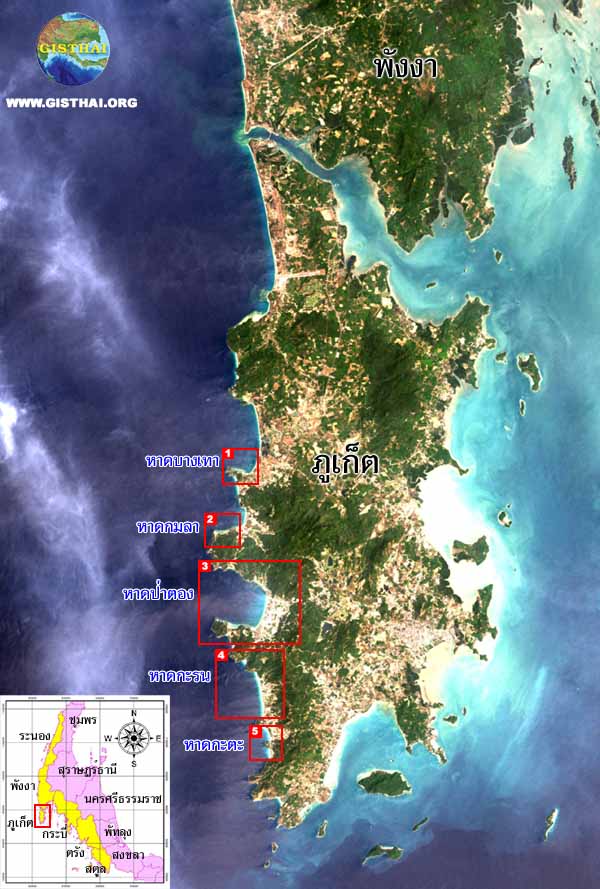
| ระนอง : Ranong | | | พังงา : Phangnga | | | ภูเก็ต : Phuket | | | กระบี่ : Krabi | | | ตรัง : Trang | | | สตูล : Satun |
โดย ผู้ช่วยศาสตราจารย์ สมบัติ อยู่เมือง และทีมงานวิจัย
ศูนย์วิจัยภูมิสารสนเทศเพื่อประเทศไทย [ GISTHAI ] จุฬาลงกรณ์มหาวิทยาลัย
e - mail : sombat@gisthai.org
By Assistant Professor Sombat Yumuang et al.
Geo-InformaticS Center for Thailand [ GISTHAI ] Chulalongkorn University
ภาพข้อมูลจากดาวเทียม IKONOS ได้รับความอนุเคราะห์จาก สำนักพัฒนาเทคโนโลยีอวกาศและภูมิสารสนเทศ (องค์การมหาชน) - สทอภ.
 |
|
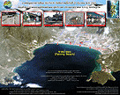
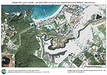
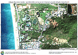
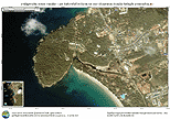
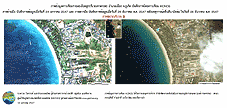
ภาพสามมิติแสดง ภาพข้อมูลจากดาวเทียม Ikonos ซ้อนทับแบบจำลองลักษณะภูมิประเทศ บริเวณหาดป่าตอง จ.ภูเก็ต A prespective view of Ikonos satellite image overlaid with simulated topography of Patong Beach, Phuket |
||
|
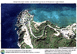
เป็นภาพที่ถ่ายเมื่อวันที่ 24 มกราคม 2547 Satellite image acquired on 24 January 2004 |
เป็นภาพที่ถ่ายเมื่อวันที่ 29 ธันวาคม 2547 Satellite image acquired on 29 December 2004 |
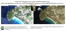
ภาพเคลื่อนไหวสามมิติ จากหาดทรายแก้วไปยังหาดบางเทา จ.ภูเก็ต (3D animation from Saikaew to Bangtao Beach Phuket Province ) |
 |
 |
 |
|
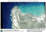
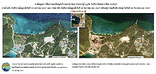
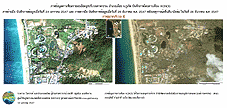
ภาพก่อนเกิดเหตุการณ์ Satellite Image in pre-tsunami disaster |
ภาพหลังเกิดเหตุการณ์ 3 วัน Satellite Images in post-three day tsunami disaster |
Download File |
|
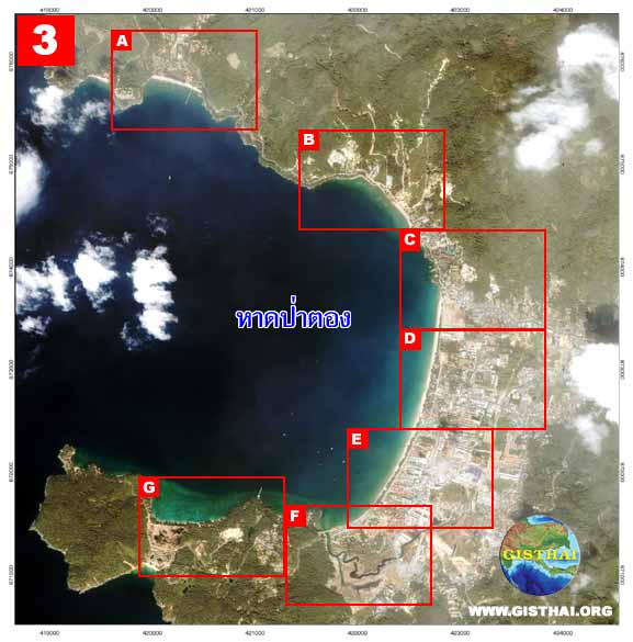
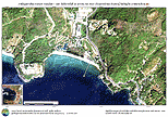
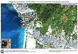
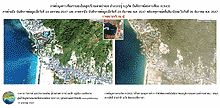
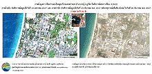
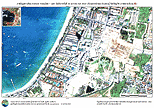
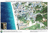
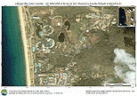
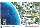
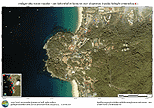
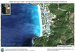
ภาพข้อมูลดาวเทียม IKONOS รายละเอียด 1 เมตร บริเวณหาดป่าตอง อ.กะทู้ จ.ภูเก็ต บันทึกเมื่อวันที่ 29 ธันวาคม พ.ศ. 2547 Ikonos satellite image, with 1 meter resolution, of Patong Beach acquired on 29 December 2004 |
||
|
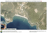
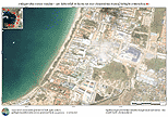
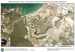
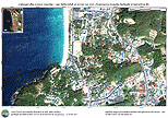
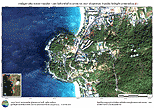
ภาพข้อมูลดาวเทียม IKONOS บริเวณ จ.ภูเก็ต บันทึกเมื่อวันที่ 24 มกราคม พ.ศ. 2547 Ikonos satellite image of Phuket acquired on 24 January 2004 |
 |
|
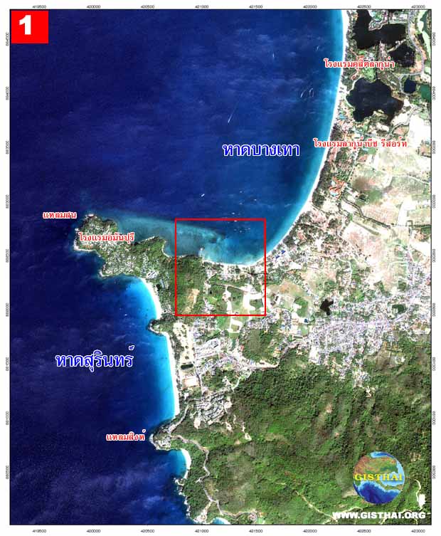
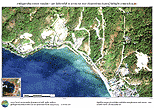
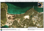
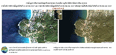
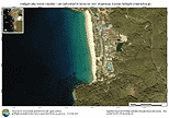
ภาพข้อมูลจากดาวเทียม IKONOS รายละเอียด 1 เมตร บริเวณหาดบางเทา อ.กะทู้ จ.ภูเก็ต บันทึกเมื่อวันที่ 29 ธันวาคม พ.ศ. 2547 Ikonos satellite image, with 1 meter resolution, of Bangtao Beach acquired on 29 December 2004 |
 |
|
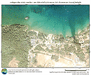
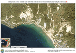
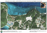
ภาพข้อมูลดาวเทียม IKONOS รายละเอียด 1 เมตร บริเวณหาดกมลา อ.เมือง จ.ภูเก็ต บันทึกเมื่อวันที่ 29 ธันวาคม พ.ศ. 2547 Ikonos satellite image, with 1 meter resolution, of Kamala Beach acquired on 29 December 2004 |
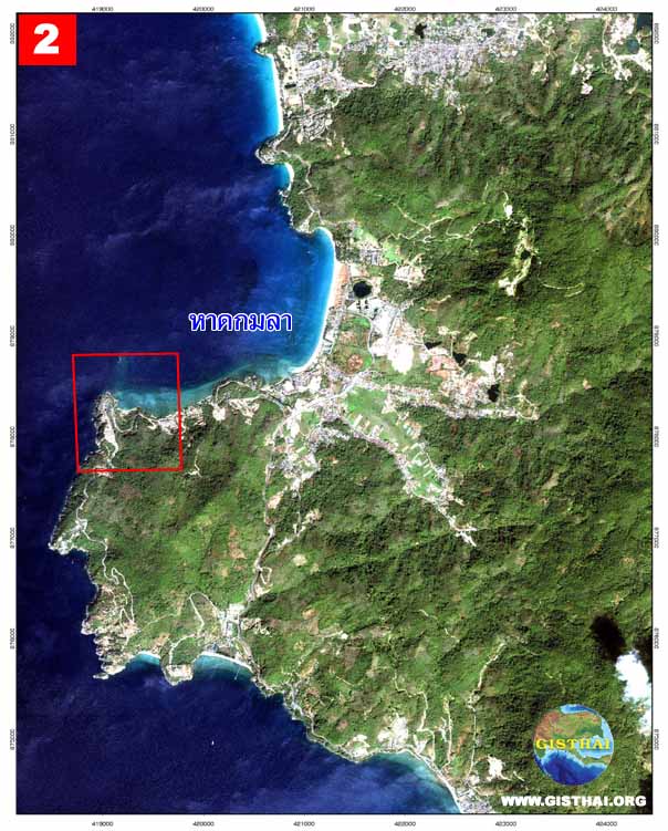 |
| ภาพขยาย หาดกมลา (Zooming Images of Kamala Beach) บริเวณ กรอบสีแดง (red box) | ||
 |
 |
 |
|
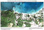
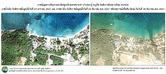
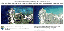
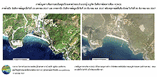
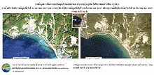
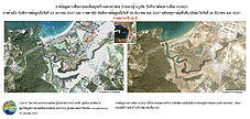
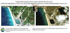
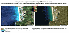
ภาพข้อมูลดาวเทียม IKONOS บริเวณหาดกมลา [บันทึกภาพเมื่อ 24 ม.ค. 2547] Ikonos satellite image of Kamala Beach acquired on 24 January 2004 |
ภาพข้อมูลดาวเทียม IKONOS บริเวณหาดกมลา [บันทึกภาพเมื่อ 29 ธ.ค. 2547] Ikonos satellite image of Kamala Beach acquired on 29 December 2004 |
ภาพข้อมูลดาวเทียม IKONOS บริเวณหาดกมลา ก่อนและหลังการเกิด tsunami Ikonos satellite image of Kamala Beach in pre and post tsunami disaster |
|
Download รูป |
Download รูป |
Download รูป |
|
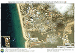
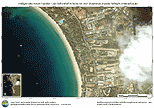
ภาพข้อมูลดาวเทียม IKONOS รายละเอียด 1 เมตร บริเวณหาดป่าตอง อ.กะทู้ จ.ภูเก็ต บันทึกเมื่อวันที่ 29 ธันวาคม พ.ศ. 2547 Ikonos satellite image, with 1 meter resolution, of Patong Beach acquired on 29 December 2004 |
 |
| ภาพขยาย หาดป่าตอง (Zooming Images of Patong Beach) บริเวณ A (Zone A) | ||
 |
 |
 |
|
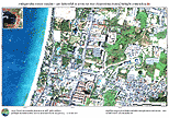
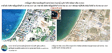
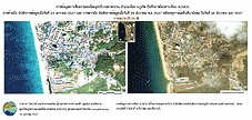
ภาพข้อมูลดาวเทียม IKONOS บริเวณหาดป่าตอง [บันทึกภาพเมื่อ 24 ม.ค. 2547] Ikonos satellite image of Patong Beach acquired on 24 January 2004 |
ภาพข้อมูลดาวเทียม IKONOS บริเวณหาดป่าตอง [บันทึกภาพเมื่อ 29 ธ.ค. 2547] Ikonos satellite image of Patong Beach acquired on 29 December 2004 |
ภาพข้อมูลดาวเทียม IKONOS บริเวณหาดป่าตอง ก่อนและหลังการเกิด tsunami Ikonos satellite image of Patong Beach in pre and post tsunami disaster |
|
Download รูป |
Download รูป |
Download รูป |
| ภาพขยาย หาดป่าตอง (Zooming Images of Patong Beach) บริเวณ B (Zone B) | ||
 |
 |
 |
|
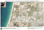
ภาพข้อมูลดาวเทียม IKONOS บริเวณหาดป่าตอง [บันทึกภาพเมื่อ 24 ม.ค. 2547] Ikonos satellite image of Patong Beach acquired on 24 January 2004 |
ภาพข้อมูลดาวเทียม IKONOS บริเวณหาดป่าตอง [บันทึกภาพเมื่อ 29 ธ.ค. 2547] Ikonos satellite image of Patong Beach acquired on 29 December 2004 |
ภาพข้อมูลดาวเทียม IKONOS บริเวณหาดป่าตอง ก่อนและหลังการเกิด tsunami Ikonos satellite image of Patong Beach in pre and post tsunami disaster |
|
Download รูป |
Download รูป |
Download รูป |
| ภาพขยาย หาดป่าตอง (Zooming Images of Patong Beach) บริเวณ C (Zone C) | ||
 |
 |
 |
|
ภาพข้อมูลดาวเทียม IKONOS บริเวณหาดป่าตอง [บันทึกภาพเมื่อ 24 ม.ค. 2547] Ikonos satellite image of Patong Beach acquired on 24 January 2004 |
ภาพข้อมูลดาวเทียม IKONOS บริเวณหาดป่าตอง [บันทึกภาพเมื่อ 29 ธ.ค. 2547] Ikonos satellite image of Patong Beach acquired on 29 December 2004 |
ภาพข้อมูลดาวเทียม IKONOS บริเวณหาดป่าตอง ก่อนและหลังการเกิด tsunami Ikonos satellite image of Patong Beach in pre and post tsunami disaster |
|
Download รูป |
Download รูป |
Download รูป |
| ภาพขยาย หาดป่าตอง (Zooming Images of Patong Beach) บริเวณ D (Zone D) | ||
 |
 |
 |
|
ภาพข้อมูลดาวเทียม IKONOS บริเวณหาดป่าตอง [บันทึกภาพเมื่อ 24 ม.ค. 2547] Ikonos satellite image of Patong Beach acquired on 24 January 2004 |
ภาพข้อมูลดาวเทียม IKONOS บริเวณหาดป่าตอง [บันทึกภาพเมื่อ 29 ธ.ค. 2547] Ikonos satellite image of Patong Beach acquired on 29 December 2004 |
ภาพข้อมูลดาวเทียม IKONOS บริเวณหาดป่าตอง ก่อนและหลังการเกิด tsunami Ikonos satellite image of Patong Beach in pre and post tsunami disaster |
|
Download รูป |
Download รูป |
Download รูป |
| ภาพขยาย หาดป่าตอง (Zooming Images of Patong Beach) บริเวณ E (Zone E) | ||
 |
 |
 |
|
ภาพข้อมูลดาวเทียม IKONOS บริเวณหาดป่าตอง [บันทึกภาพเมื่อ 24 ม.ค. 2547] Ikonos satellite image of Patong Beach acquired on 24 January 2004 |
ภาพข้อมูลดาวเทียม IKONOS บริเวณหาดป่าตอง [บันทึกภาพเมื่อ 29 ธ.ค. 2547] Ikonos satellite image of Patong Beach acquired on 29 December 2004 |
ภาพข้อมูลดาวเทียม IKONOS บริเวณหาดป่าตอง ก่อนและหลังการเกิด tsunami Ikonos satellite image of Patong Beach in pre and post tsunami disaster |
|
Download รูป |
Download รูป |
Download รูป |
| ภาพขยาย หาดป่าตอง (Zooming Images of Patong Beach) บริเวณ F (Zone F) | ||
 |
 |
 |
|
ภาพข้อมูลดาวเทียม IKONOS บริเวณหาดป่าตอง [บันทึกภาพเมื่อ 24 ม.ค. 2547] Ikonos satellite image of Patong Beach acquired on 24 January 2004 |
ภาพข้อมูลดาวเทียม IKONOS บริเวณหาดป่าตอง [บันทึกภาพเมื่อ 29 ธ.ค. 2547] Ikonos satellite image of Patong Beach acquired on 29 December 2004 |
ภาพข้อมูลดาวเทียม IKONOS บริเวณหาดป่าตอง ก่อนและหลังการเกิด tsunami Ikonos satellite image of Patong Beach in pre and post tsunami disaster |
|
Download รูป |
Download รูป |
Download รูป |
| ภาพขยาย หาดป่าตอง (Zooming Images of Patong Beach) บริเวณ G (Zone G) | ||
 |
 |
 > > |
|
ภาพข้อมูลดาวเทียม IKONOS บริเวณหาดป่าตอง [บันทึกภาพเมื่อ 24 ม.ค. 2547] Ikonos satellite image of Patong Beach acquired on 24 January 2004 |
ภาพข้อมูลดาวเทียม IKONOS บริเวณหาดป่าตอง [บันทึกภาพเมื่อ 29 ธ.ค. 2547] Ikonos satellite image of Patong Beach acquired on 29 December 2004 |
ภาพข้อมูลดาวเทียม IKONOS บริเวณหาดป่าตอง ก่อนและหลังการเกิด tsunami Ikonos satellite image of Patong Beach in pre and post tsunami disaster |
|
Download รูป |
Download รูป |
Download รูป |
|
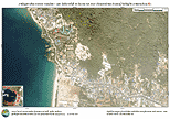
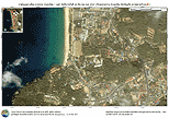
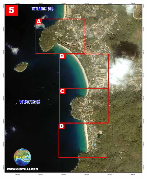
ภาพข้อมูลดาวเทียม IKONOS รายละเอียด 1 เมตร บริเวณหาดกะรน อ.เมือง จ.ภูเก็ต บันทึกเมื่อวันที่ 29 ธันวาคม พ.ศ. 2547 Ikonos satellite image, with 1 meter resolution, of Karon Beach acquired on 29 December 2004 |
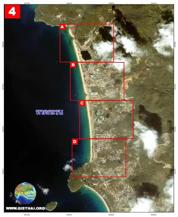 |
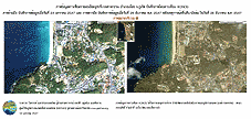
| ภาพขยาย หาดกะรน (Zooming Images of Karon Beach) บริเวณ A (Zone A) | ||
 |
 |
 |
|
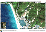
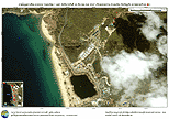
ภาพข้อมูลดาวเทียม IKONOS บริเวณหาดกะรน [บันทึกภาพเมื่อ 24 ม.ค. 2547] Ikonos satellite image of Karon Beach acquired on 24 January 2004 |
ภาพข้อมูลดาวเทียม IKONOS บริเวณหาดกะรน [บันทึกภาพเมื่อ 29 ธ.ค. 2547] Ikonos satellite image of Karon Beach acquired on 29 December 2004 |
ภาพข้อมูลดาวเทียม IKONOS บริเวณหาดกะรน ก่อนและหลังการเกิด tsunami Ikonos satellite image of Karon Beach in pre and post tsunami disaster |
|
Download รูป |
Download รูป |
Download รูป |
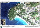
| ภาพขยาย หาดกะรน (Zooming Images of Karon Beach) บริเวณ B (Zone B) | ||
 |
 |
 |
|
ภาพข้อมูลดาวเทียม IKONOS บริเวณหาดกะรน [บันทึกภาพเมื่อ 24 ม.ค. 2547] Ikonos satellite image of Karon Beach acquired on 24 January 2004 |
ภาพข้อมูลดาวเทียม IKONOS บริเวณหาดกะรน [บันทึกภาพเมื่อ 29 ธ.ค. 2547] Ikonos satellite image of Karon Beach acquired on 29 December 2004 |
ภาพข้อมูลดาวเทียม IKONOS บริเวณหาดกะรน ก่อนและหลังการเกิด tsunami Ikonos satellite image of Karon Beach in pre and post tsunami disaster |
|
Download รูป |
Download รูป |
Download รูป |
| ภาพขยาย หาดกะรน (Zooming Images of Karon Beach) บริเวณ C (Zone C) | ||
 |
 |
 |
|
ภาพข้อมูลดาวเทียม IKONOS บริเวณหาดกะรน [บันทึกภาพเมื่อ 24 ม.ค. 2547] Ikonos satellite image of Karon Beach acquired on 24 January 2004 |
ภาพข้อมูลดาวเทียม IKONOS บริเวณหาดกะรน [บันทึกภาพเมื่อ 29 ธ.ค. 2547] Ikonos satellite image of Karon Beach acquired on 29 December 2004 |
ภาพข้อมูลดาวเทียม IKONOS บริเวณหาดกะรน ก่อนและหลังการเกิด tsunami Ikonos satellite image of Karon Beach in pre and post tsunami disaster |
|
Download รูป |
Download รูป |
Download รูป |
| ภาพขยาย หาดกะรน (Zooming Images of Karon Beach) บริเวณ D (Zone D) | ||
 |
 |
 |
|
ภาพข้อมูลดาวเทียม IKONOS บริเวณหาดกะรน [บันทึกภาพเมื่อ 24 ม.ค. 2547] Ikonos satellite image of Karon Beach acquired on 24 January 2004 |
ภาพข้อมูลดาวเทียม IKONOS บริเวณหาดกะรน [บันทึกภาพเมื่อ 29 ธ.ค. 2547] Ikonos satellite image of Karon Beach acquired on 29 December 2004 |
ภาพข้อมูลดาวเทียม IKONOS บริเวณหาดกะรน ก่อนและหลังการเกิด tsunami Ikonos satellite image of Karon Beach in pre and post tsunami disaster |
|
Download รูป |
Download รูป |
Download รูป |
|
ภาพข้อมูลดาวเทียม IKONOS รายละเอียด 1 เมตร บริเวณหาดกะตะ อ.เมือง จ.ภูเก็ต บันทึกเมื่อวันที่ 29 ธันวาคม พ.ศ. 2547 Ikonos satellite image, with 1 meter resolution, of Kata Beach acquired on 29 December 2004 |
 |
| ภาพขยาย หาดกะตะ (Zooming Images of Kata Beach) บริเวณ A (Zone A) | ||
 |
 |
 |
|
ภาพข้อมูลดาวเทียม IKONOS บริเวณหาดกะตะ [บันทึกภาพเมื่อ 24 ม.ค. 2547] Ikonos satellite image of Kata Beach acquired on 24 January 2004 |
ภาพข้อมูลดาวเทียม IKONOS บริเวณหาดกะตะ [บันทึกภาพเมื่อ 29 ธ.ค. 2547] Ikonos satellite image of Kata Beach acquired on 29 December 2004 |
ภาพข้อมูลดาวเทียม IKONOS บริเวณหาดกะตะ ก่อนและหลังการเกิด tsunami Ikonos satellite image of Kata Beach in pre and post tsunami disaster |
|
Download รูป |
Download รูป |
Download รูป |
| ภาพขยาย หาดกะตะ (Zooming Images of Kata Beach) บริเวณ B (Zone B) | ||
 |
 |
 |
|
ภาพข้อมูลดาวเทียม IKONOS บริเวณหาดกะตะ [บันทึกภาพเมื่อ 24 ม.ค. 2547] Ikonos satellite image of Kata Beach acquired on 24 January 2004 |
ภาพข้อมูลดาวเทียม IKONOS บริเวณหาดกะตะ [บันทึกภาพเมื่อ 29 ธ.ค. 2547] Ikonos satellite image of Kata Beach acquired on 29 December 2004 |
ภาพข้อมูลดาวเทียม IKONOS บริเวณหาดกะตะ ก่อนและหลังการเกิด tsunami Ikonos satellite image of Kata Beach in pre and post tsunami disaster |
|
Download รูป |
Download รูป |
Download รูป |
| ภาพขยาย หาดกะตะ (Zooming Images of Kata Beach) บริเวณ C (Zone C) | ||
 |
 |
 |
|
ภาพข้อมูลดาวเทียม IKONOS บริเวณหาดกะตะ [บันทึกภาพเมื่อ 24 ม.ค. 2547] Ikonos satellite image of Kata Beach acquired on 24 January 2004 |
ภาพข้อมูลดาวเทียม IKONOS บริเวณหาดกะตะ [บันทึกภาพเมื่อ 29 ธ.ค. 2547] Ikonos satellite image of Kata Beach acquired on 29 December 2004 |
ภาพข้อมูลดาวเทียม IKONOS บริเวณหาดกะตะ ก่อนและหลังการเกิด tsunami Ikonos satellite image of Kata Beach in pre and post tsunami disaster |
|
Download รูป |
Download รูป |
Download รูป |
| ภาพขยาย หาดกะตะ (Zooming Images of Kata Beach) บริเวณ D (Zone D) | ||
 |
 |
 |
|
ภาพข้อมูลดาวเทียม IKONOS บริเวณหาดกะตะ [บันทึกภาพเมื่อ 24 ม.ค. 2547] Ikonos satellite image of Kata Beach acquired on 24 January 2004 |
ภาพข้อมูลดาวเทียม IKONOS บริเวณหาดกะตะ [บันทึกภาพเมื่อ 29 ธ.ค. 2547] Ikonos satellite image of Kata Beach acquired on 29 December 2004 |
ภาพข้อมูลดาวเทียม IKONOS บริเวณหาดกะตะ ก่อนและหลังการเกิด tsunami Ikonos satellite image of Kata Beach in pre and post tsunami disaster |