
The Application of GIS and Remote Sensing on Assessing Physical Impact Caused by Tsunami on Dec,26 2004 in the Coastal Zone of Thailand
| ระนอง : Ranong | | พังงา : Phangnga | | ภูเก็ต : Phuket | | กระบี่ : Krabi | | ตรัง : Trang | | สตูล : Satun |
โดย ผู้ช่วยศาสตราจารย์ สมบัติ อยู่เมือง และทีมงานวิจัย
ศูนย์วิจัยภูมิสารสนเทศเพื่อประเทศไทย [ GISTHAI ] จุฬาลงกรณ์มหาวิทยาลัย
e - mail : [email protected]
By Assistant Professor Sombat Yumuang et al.
Geo-InformaticS Center for Thailand [ GISTHAI ] Chulalongkorn University
 |
|
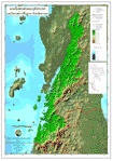
แผนที่แสดงลักษณะภูมิประเทศ (Topographical Map) |
 |
 |
 |
|
แผนที่ภูมิประเทศที่เกี่ยวข้อง และ เกิดผลกระทบจากการเกิด tsunamis ถล่ม และแสดงโซนพื้นที่ Relevant topographical maps showed the areas destroyed by Tsunami |
แผนที่แสดงเขตอุทยานแห่งชาติ Boundary Map of National Park |
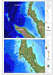
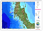
แผนที่แสดงลักษณะภูมิประเทศ และ โครงสร้างพื้นที่จังหวัดระนอง Topographical Map and Infrastructure of Ranong Province |
|
Download รูป |
Download รูป |
Download รูป  |
| แผนที่ภาพถ่ายจากดาวเทียม (Satellite Image) |
 |
||
|
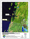
แผนที่บริเวณอำเภอกะเปอร์ และกิ่งอำเภอสุขสำราญ จังหวัดระนองที่ได้รับความเสียหายจากคลื่นยักษ์ (Tsunamis) เมื่อวันที่ 26 ธ.ค. 2547 Map of Location of Amphoe Kapur and King Amphoe Sooksumran Ranong Province was damaged by Tsunami on 26 December 2004 |
||
|
Download รูป |